- Places
- Plans
- Itineraries
- Experiences
When the air raid sirens went off, I looked out the window of my hotel just off Piazza San Marco to discover that my street had, overnight, become a canal.
This is not unusual for Venice—not so much because it is sinking (which it is, slowly), but because the way it was built, its slow drainage system (and nonexistent sewer system), and the way the tides work on the Adriatic Sea.
The result: several times throughout the winter months, Venice inadvertently invites the lagoon to backwash into its lower-lying regions.
Although they're creating mechanical dams between the barrier islands to prevent this (in a project cleverly acronymed MOSE—in the Italian spelling, the Old Testament prophet famous for parting the Red Sea doesn't have an "S" at the end of his name—learn more about it on the Context: Science and Secrets of the Lagoon boat tour), every winter season the tides bring the Adriatic Sea rushing into Venice's Lagoon—and the lagoon rushing into the streets.
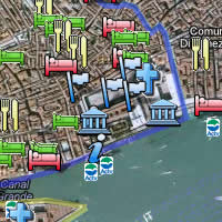
When the acque alte strike, usually between October and March with a peak in December (though they can happen year-round), low-lying Piazza San Marco is the first area to give up the ship—its the lowest point in the city, at a whopping 64cm—about two feet—above sea level.
Once the seas rise above 65cm, you're looking at water at least in Piazzetta San Marco (the arm of Piazza San Marco that starts between the campanile and St. Mark's cathedral and extends past the Doge's Palace to the Bacino San Marco basin).
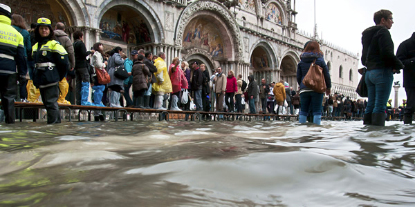
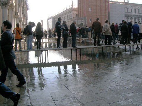
The flooding spreads from there, but usually doesn't inundate the entire city—which has no problem handling water up to 120cm with a combination of patience and passarelle.
As the waters rise, you may find yourself having the peculiarly Venetian experience of walking about the inundated city along lifelines of jerryrigged wooden planks, temporary boardwalks called passarelle which make it took for all the world as if the city is about to host a giant picnic for people under three feet tall.
The sirens and the tones
You'll know the waters are coming when you hear the old-fashioned air raid sirens keen mournfully—if you've never heard an air raid siren, they sound exactly like they did in World War II movies. This just tells you the water is coming. In 2007, the city introduced a system that also alerts residents as to how much water is coming. After the siren, you'll likely hear one or more ascending tones—like a postmodern bell tolling the hours—with a single tone for 110 cm, two tones for 120cm, and so on. More than four tones, and you know you're in trouble.
Though it wreaks havoc on local ground-level businesses (look at the doorways of every entrance in the San Marco neighborhood; there are little vertical grooves on either side of the door jamb for slipping in a sheet of metal as a temporary dam), I choose to view the acque alte as a magical time.
The city takes on the air of a "snow day," everybody seems to get a little bit nicer and more neighborly, and it certainly changes your view on things.
Just borrow a pair of trash bags from your hotelier to pull over your feet and lower legs, head outside, and slosh your way up the street until you get to a major enough thoroughfare where they're erected those wooden walkways.
Then you can spend the day boardwalking your way throughout Venice, seeing the sights while walking atop the waters.
You can get daily sea level reports from the city of Venice at: www.comune.venezia.it/maree—where you can also find maps of the passarelle walkways download free iPhone and Android apps that update you with predictions, warnings, and real-time flooding maps.
(Local newspapers also report daily predictions along with the weather, and there are public displays of predictions in Piazzale Roma and on a board by the campanile (bell tower) in Piazza San Marco—which I always found amusing, since if you're standing there looking at the sign you already know whether or not it is acqua alta time as this is the first spot in all of Venice to flood.)
Roughly 78% of the historic center lies between 110cm and 140cm above sea level, and—until recently—the waters only slopped over 110cm about a half-dozen times per year at most (usually in the dead of winter, especially December). Very rarely do they top 120cm, the unofficial upper limit when most of the passarelle are still above water.
And then, on December 1, 2008, the lagoon roared in at 156cm above sea level—the highest level in more than two decades—effectively drowning most of the city for a day.
What has followed has been ominous. Remember: Until recently, the acqua alta had only gone over 110cm about 6 times per year on average. In just the past seven years, that number has jumped to an average of 10.
Here is how many days the water topped 80cm and 110cm in each year since 2008:
| Year | over 80cm | over 110cm | high water mark | percentage of year Piazza San Marco spent under water |
| 2008 | 80 days | 6 days | 156cm | 22% |
| 2009 | 125 days | 16 days | 145cm | 34% |
| 2010 | 203 days | 18 days | 144cm | 56% |
| 2011 | 60 days | 1 day | 112cm | 16% |
| 2012 | 105 days | 9 days | 149cm | 29% |
| 2013 | 156 days | 6 days | 143cm | 43% |
| 2014 | 189 days | 12 days | 125cm | 52% |
| 2015 (as of Apr.) | 29 days | 6 days | 124cm | 25% |
Acque Alte warning service
Istituzione Centro Previsioni e Segnalazioni Maree
tel. +39-041-241-1996 (recorded info in Italian); 041-274-8787 to talk to someone (in Italian)
Central clearinghouse for all data, warnings, and info on the acque alte (including iPhone and Android prediction/warning apps):
www.comune.venezia.it/maree
Tour that visits the MOSE damming project
Share this page
Search ReidsItaly.com
Acque Alte warning service
Istituzione Centro Previsioni e Segnalazioni Maree
tel. +39-041-241-1996 (recorded info in Italian); 041-274-8787 to talk to someone (in Italian)
Central clearinghouse for all data, warnings, and info on the acque alte (including iPhone and Android prediction/warning apps):
www.comune.venezia.it/maree
Tour that visits the MOSE damming project

This article was written by Reid Bramblett and was last updated in April 2015
.
All information was accurate at the time.
about | contact | faq
» THE REIDSITALY.COM DIFFERENCE «
åß
Copyright © 2008–2017 by Reid Bramblett. Author: Reid Bramblett