- Places
- Plans
- Itineraries
- Experiences
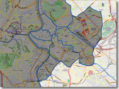
A rundown of the main streets, piazzas, and neighborhoods to help you navigate the Eternal City
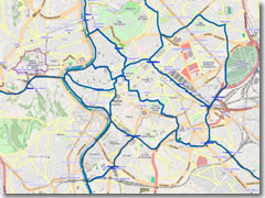
Rome is strung along an S-shaped bend of the Tevere (Tiber River). The bulk of the centro storico (historic center) lies east of the Tevere. The Vatican and Trastevere lie on the west banks of the Tiber.For the purposes of major roads and arteries, know this: for all intents and purposes the geographic center of Rome is Piazza Venezia; everything radiates out from this point. Dividing the city into neighborhoods is a bit trickier.
There are many ways to slice the map of Rome into smaller, bite-sized neighborhoods: the famous Seven Hills of antiquity, the medieval rioni neighborhood designations that are still used officially but mean little to non-Romans. (Sure, you've heard of the rione called Trastevere, but what about rione Borgo? Unlikely; but if I said "Area around the Vatican" you'd instantly know where the Borgo was.)
However, most official divisions are fairly useless to the traveler. Most tourists simply want to know which area of town is which, where the big sights are, and where they would they be happiest finding a hotel.
A quarter-century of living on-and-off in Rome has taught me that, regardless of historic or official demarcation lines—or even of major streets of squares—once you're on the ground and walking around, the Rome a visitor sees naturally falls into about 11 neighborhoods (well, 10 neighborhoods plus one for everything "beyond the walls").
Those are the ones I will use. I'll label some descriptively, some using the rione name, and some using the good ol' Seven Hills, but each will be anchored by two or three major sights or landmarks so you'll know where I'm talking about.
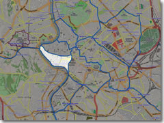
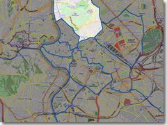
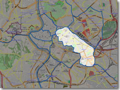
We'll start with the three neighborhoods at the very heart of the historic center, the area 90% of tourists want to spend most of their time in: The Tridente, Upper Tiber Bend, and Lower Tiber Bend.
 Since the 18th century, this has been one of the most popular ex-pat areas of Rome, full of Brits and Germans and lots of passeggiata (evening stroll) action.
It's no coincidence Rome's top hotels cluster at the Steps' summit, or that the American Express is on Piazza di Spagna itself (and that Italy's first McDonald's opened a few doors down in 1986, nearly inciting a riot by Italian food traditionalists).
Moving about this neighborhood is often an exercise in weaving between large clots of camera-clicking tour groups, but the area certainly stays animated and most roads are blessedly closed to cars. It's one of the most touristy areas of the center, with "public living rooms" and patented tourist draws like the graceful baroque off-center sweep of the Spanish Steps and the gushing mountain of white marble called the Trevi Fountain.
Although hotels and restaurants in the Tridente tend to be expensive and touristy, it's a pleasantly pedestrianized zone with some good budget values if you look hard enough.
The north end of the tourist's city is the oval Piazza del Popolo. From this obelisk-sporting square, three major roads radiate south (which is why this area is called "The Trident"): Via del Babuino, Via del Corso, and Via di Ripetta. The middle one, Via del Corso (usually just called "Il Corso"), divides the heart of the city in half.
To the east of the Corso lie the Spanish Steps (whence leads art-gallery-lined Via del Babuino) and the Trevi Fountain. The streets around Piazza di Spagna (which how Italians refer to what we call the Spanish Steps) comprise the heart of Rome's most stylish shopping scene, with boutique-lined streets like Via de' Condotti (running straight from the Spanish Steps to the Corso) sporting the biggest names in Italian and international fashion.
The southern boundary of the Tridente is really the large Fascist piazza around the ancient Ara Pacis altar and adjacent Augustus' Mausoleum. However the Corso keeps going, past the Tiber Bend area described below, to end at what is, for all intents and purposes, Rome's center: Piazza Venezia. This major traffic circle and bus juncture is marked by the overbearing, garishly white Vittorio Emanuele II Monument ("Il Vittoriano"), which you can now climb for free (until sunset) for low-angle city panoramas.
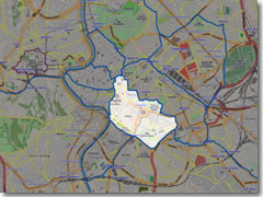
To the west of the Corso, south of the Ara Pacis altar and Augustus' Mausoleum, spreads the medieval Tiber Bend area, which is so large and crammed with major sights (not to mention hotels and restaurants) that it's easier to divide into two sections: Upper Tiber Bend and Lower Tiber Bend (descriptions to follow in a sec).
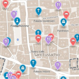
These two areas are neatly divided by Via Plebescito, which heads west from Piazza Venezia then, after passing through the archaeological site–cum–major bus stop Largo di Torre Argentina/Largo Arenula, becomes Corso Vittorio Emanuele II. This wide street effectively bisects the Tiber Bend as it heads toward the river and the Vatican. (Piazza Navona and the Pantheon lie to the north, Campo de' Fiori and the Jewish Ghetto to the south.)
 West of the Corso and north of Corso Vittorio Emanuele II is the tourist-jammed Upper Tiber Bend area.
This is the true heart of Medieval Rome, home to landmarks such as the bustling Piazza Navona and the ancient Pantheon and a host of other sights and monuments: countless churches hiding Caravaggio paintings or Michelangelo sculptures, a few small museums, and plenty of pedestrian-only elbow room.
This area is chock-a-block with great restaurants and—surprisingly—has some good, inexpensive lodging. You're also within easy walking distance of both the Vatican and the ruins of Ancient Rome.
It's a toss-up between this and the Spanish Steps area when it comes to choosing the absolute best place to base yourself in Rome (sightseeing fanatics will want to book here; shoppers nearer the Spanish Steps).
This working-class neighborhood of the Tiber Bend, strung between the river and Corso V. Emanuele II, has lots of good restaurants, a daily market on Campo de' Fiori, Renaissance palaces lining the Via Giulia, and a burgeoning nightlife scene on and around Campo dei Fiori (called simply "The Campo" by the hordes of American study abroad students and their buddies who descend upon it nightly to party).
The eastern half of the area—between Via Arenula and Via di Teatro Marcello, and below Largo di Torre Argentina—has been home to Europe's oldest Jewish population ever since it was a walled ghetto in the 16th century.
Roman Jewish cooking is some of the city's best, and you'll find delicious and relatively inexpensive examples in trattorie and restaurants scattered throughout this entire zone. There are also a bunch of excellent-value hotels (though be warned: those right off Campo de' Fiori do suffer from the nightly noise of carousing 20-somethings).
 OK, ancient ruins are spread all over the city, which is why I call the heart of the ancient city—home to the Roman Forum, Imperial Fori, and the Colosseum—"Downtown Ancient Rome."
It's easy to find because it's still pretty much at the center of town, just south of Piazza Venezia. Back at Piazza Venezia and facing south, go to the right around the Vittorio Emanuele Monument and you'll see a Michelangelo-designed stair ramp leading up behind it to the Campidoglio (Capitoline Hill), Rome's seat of government.
Around the left side of the monument is Via dei Fori Imperiali, a wide boulevard making a beeline from Piazza Venezia to the Colosseum, passing the archaeological zone of the Roman Forum on the right (slung into the low land between the Capitoline and Palatine Hills) and the Imperial Fori on the left.
Antiquity buffs will want to spend a lot of their visit in this vast archaeological zone, but it offers few good hotels and even fewer decent restaurants (most cater to entire tour buses with bad food at high prices).
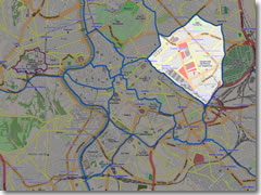 The neighborhoods described above are the areas of Rome where you'll spend most of your time. But the first part of the city you'll see lies east of all this, in the grid of 19th-century streets surrounding the main train station, Termini.
Although an abundance of budget hotels surround the station, this area should be your last choice for where to stay.
Aside from some churches and one great museum (Palazzo Massimo), it's a generally boring area, too far from the bulk of Rome's sights to walk, and, though much cleaned up in recent years, still seedy, especially after dark. It's pretty much the least safe area in central Rome, with a higher rate of pick pocketing and mugging.
Unless you're concerned about catching a train to make an early flight, I'd find a hotel in a safer, more interesting, and central part of town.
Just so you know: The streets north of Termini are somewhat cleaner and safer than those south of Termini. (Note to old Rome hands: Yes, this is the reverse of the way things were in the before the mid-1990s.) East of Termini is the University district of San Lorenzo, home to some fantastic restaurants.
 Northwest of Termini (east of the Spanish Steps) is a boulevard zone where many foreign embassies lie, the highlight being the lazy S-curve of the cafe-lined Via Veneto.
In the 1950s, this was the heartbeat of La Dolce Vita ("the sweet life") made famous by Fellini films. Via Veneto still has the cafes of its heyday, but today they're overpriced and patronized mainly by tourists, and its grand old hotels are similarly expensive and booked mostly by guided and packaged tours.
The area around Via Veneto and Piazza Barberini is also full of baroque and 19th-century palazzi, today home to everything from embassies to one of Rome's best painting galleries (in Palazzo Barberini) to newspaper headquarters.
Via Veneto ends at the giant Villa Borghese park, studded with museums (including the awesome Galleria Borghese) and expanding northeast of the centro storico. (It's also accessible from Piazza del Popolo.)
 The area south of Termini train station is unlikely to win anybody's "favorite bit of Rome" award. Much of it is bland and dirty, a grid of streets laid out in the 19th century and now a bit run-down and seedy (it's probably the least salubrious part of central Rome to wander after dark).
There isn't too much to tempt a tourist here—other than cheap hotels and even cheaper shops (selling frankly cheap goods)—aside from a few keynote sights, including one of the great ancient basilicas to Rome, Santa Maria Maggiore, and the church of San Pietro in Vincoli nearish the Forum, housing Michelangelo's Moses and the titular St. Peter's chains.
Well to the south rises Rome's Cathedral of San Giovanni in Laterano. (Bet you thought St. Peter's at the Vatican was the cathedral. Nope. The Pope's bishopric is actually based here.)
Incidentally, the unwieldy name I chose for this neighborhood honors three of the famous Seven Hills of Rome from antiquity: the Esquiline (atop which now sits Santa Maria Maggiore) and, to its northwest, the Viminal and Quirinal, both of which house the palaces containing major offices of the Italian national government. These include the Ministry of the Interior on the Viminal, and the palace of the president atop the Quirinal (in fact, in Italian the term "Quirinale" is used to refer to the government in conversation and news reports, just like Americans refer to "the White House" as if it were an entity). However, since most government buildings are off-limits to the general public, this is a bit of a black hole on the tourism map, with little to visit.
 Across the Tiber are two major neighborhoods, and the first one all tourists flock to is the one called the Borgo.
This the area surrounding the Vatican is full of tour buses and the restaurants and businesses that cater to them, but also many modestly priced (if mostly boringly modern) hotels.
Mussolini razed a medieval district to lay down the wide Via della Conciliazione, linking the Ponte Vittorio Emanuele and Castel Sant'Angelo with Vatican City and St. Peter's.
Expanding north and northeast of the Borgo is the residential and shopping zone of Prati—no sightseeing, just a good glimpse into the daily life of middle-class Romans.
 South of the Vatican, past the long park-like Gianicolo (Janiculum Hill), lies the once medieval working-class, then trendy, and now touristy district of Trastevere.
Trastevere, which means "Across the Tiber," was another of Rome's great Medieval working-class neighborhoods, one that spoke its own distinct dialect and had a tradition of street fairs and poetry—still echoed in the July Festa de' Noantri, or "Feast of We Others."
This tangle of medieval streets, where laundry hangs picturesquely from lines strung between green-shuttered buildings and around every corner is another little church filled with artistic riches (among them, Santa Maria in Trastevere, Santa Cecilia in Trastevere, and San Francesco à Ripa), contains Rome's highest concentration of bars and restaurants. (It's also where yours truly lived in the early 1990s, and I still miss it).
However, after Trastevere became trendy in the 1970 and 80s, popular both with the Roman upper middle class and lots of ex-pat Americans, it became touristy in the 1990s. It always had lots of restaurants and excellent tiny trattorie, but this boom in popularity has filled it beyond bursting with eateries, pubs, dance halls, funky boutiques, sidewalk vendors and fortune tellers, and a constant, stifling crush of trendoids and tourists. Trastevere has now become a requisite stop for coach tours and a guided walk in travel books.
It's still one of Rome's most colorful quarters, and the best place to come if you just want to wander into a good restaurant at random, but, like the Latin Quarter in Paris or SoHo in New York, it really has degraded into a parody of itself.
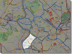 South of Downtown Ancient Rome—across the Circus Maximus from the Palatine Hill—a wonderfully quiet high-class residential district covers the Aventine Hill (Aventino).
This is an oasis of curving roads where few tourists venture and the views somehow overlook most of Rome's urban sprawl to encompass only the leafiness around you and the mountains in the distance. It’s a good place to stay if you want a vacation from the urban chaos but still to be only a stroll from the nearest bus or Metro stop.
The Aventine is home to a mini-chain of villa hotels, a handful of sadly overlooked but fantastic ancient churches (including the fifth century Santa Sabina), and some lovely views: over the Circus Maximus at the north end, over the Tiber from a tiny public park along Via Santa Sabina, and of the dome of St. Peter's from the keyhole in the gateway entrance to The Knights of Malta compound.
To the south of the Aventine, up against the river where it turns south again is one of Rome's greatest working-class neighborhoods, Testaccio, home of the old city slaughterhouse (see sidebar) and once Rome's port on the Tiber, now a hopping nightlife and restaurant district.
Testaccio is packed to the gills with cheap pizza parlors and old-fashioned trattorie where extended families hold court over four-hour dinners.
The name of this neighborhood means "ugly head" and refers to the 165-foot artificial hill at its heart. This was created in ancient times (before recycling was invented) as workers at what was then Rome's port on the Tiber would decant imported Greek wine and olive oil from their giant transport amphorae (giant terracotta vases) into smaller, more salable vessels, break the amphorae into shards, and toss them on a growing refuse pile.
That pile grew and grew into the "ugly head," now covered in grass. Since terracotta keeps constant temperature and moisture levels, tunnels and grottoes were dug into the mound for storing wine and food, and many of Rome's most authentic restaurants still line Testaccio, their dining rooms and cellars burrowed back into the artificial hill of pot shards and their kitchens turning out the most ultra-traditional cuisine in the city (see sidebar).
The area's also become rather fashionable, and most of Rome's hottest nightclubs appear in old warehouses here (and often disappear after a few months).
 This one is pretty self-explanatory, a catchall category for sighs farther afield than the neighborhoods described above comprising the historic center. Mostly, we're talking about things to the south of the center here, starting around the Piramide Metro stop and stretching south.
But just because we're no longer in the heart of old Rome doesn't mean there aren't some A-list sights outside the walls, chief among them the Catacombs, spidery networks of underground tunnels carved into the tufa where early Christians buried their dead in secret.
Then there's the ornate and antique church of St. Paul Outside the Walls, and the awesome Centrale Montemartini, an industrial-age power plant with ancient statues from the Capitoline collection scattered amidst the hulking machinery.
Planning your day: Rome wasn't built in a day, and you'd be hard-pressed to see it in that brief a time as well. Still, you can cram a lot into just a day or three.
To help you get the most out of your limited time in the Eternal City, here are some perfect itineraries, whether you have one, two, three, or four days to spend in Rome. » Rome itineraries
Share this page
Search ReidsItaly.com

This article was written by Reid Bramblett and was last updated in April 2015.
All information was accurate at the time.
about | contact | faq
» THE REIDSITALY.COM DIFFERENCE «
åß
Copyright © 2008–2017 by Reid Bramblett. Author: Reid Bramblett